Hiking in Ibiza: 12 trails for every level
Ibiza hiking trails are short and varied: clifftops at Punta Galera, pine forest on Sa Talaia (475 m, the island's highest point), almond fields in Santa Agnès and salt flats at ses Salines. The best season is October to May. In summer, walk only at sunrise and never light a fire.
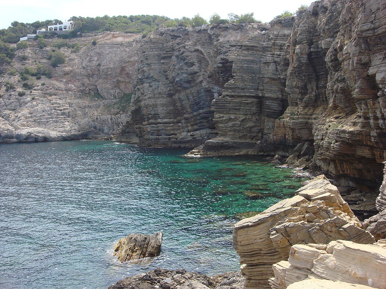
Photo: anibal amaro, CC BY 3.0, Wikimedia Commons
Ibiza isn't an island for long-distance treks, but for very varied paths packed into a small space: in one morning you can go from pine forest to a clifftop or the salt pans with their flamingos. No summit tops 475 metres: good shoes and water are all you need. Here are twelve routes, with official figures where they exist, how to get there by bus and the basic rules.
Ibiza hiking trails: when to go (and when not to)
The good hiking season is the exact opposite of the beach season: October to May. In autumn the countryside turns green again, in January and February the almond trees blossom, and in spring the hills fill with flowers before the heat arrives.
From June to September the sun is fierce and there's little shade outside the pine woods. If you walk in summer, set off at first light, finish before 11:00 and carry at least a litre and a half of water per person: heatstroke is the most common emergency for walkers on the island.
On top of that, from 1 May to 15 October is the forest fire-risk season in the Balearics (Decree 125/2007; in some drought years the regional government brings it forward). Fires of any kind are banned in and around woodland: barbecues, camping stoves, candles and, of course, dropping cigarette ends. In winter, bear in mind it gets dark around 17:30 in December and that after heavy rain the red clay gets slippery.
The 12 trails at a glance
"Official" = from the Sant Josep or Sant Antoni town hall info sheets; "approx." = our own estimate from the map.
| Trail | Area | Distance | Climb | Difficulty | Type |
|---|---|---|---|---|---|
| 1. Sa Talaia from Sant Josep | Sant Josep | 4.8 km return (official) | Moderate, steep final stretch | Easy-moderate (official) | Out and back |
| 2. Pla de Corona and sa Penya Esbarrada | Santa Agnès (Sant Antoni) | 6.8 km (official) | 100 m (official) | Easy (official) | Loop |
| 3. Cala Salada, Punta Galera and Cala Gració | Sant Antoni | 12 km (official) | 400 m (official) | Hard (official) | Returns to start |
| 4. Sant Mateu and es Camp Vell | Sant Mateu (Sant Antoni) | 10.7 km (official) | 260 m (official) | Hard (official) | Returns to start |
| 5. Es Cubells and Cala Llentrisca | Sant Josep | 9 km return (official) | Short steep sections | Moderate-hard (official) | Out and back |
| 6. Western clifftops: Cala Codolar to Platges de Comte | Sant Josep | 3.3 km (official) | Little | Moderate (official) | One way |
| 7. Torre des Savinar from Cala d'Hort | Sant Josep | About 3 km return (approx.) | Steady climb | Moderate | Out and back |
| 8. Ses Salines: the ses Portes route | Sant Josep | About 6-7 km (approx.) | Flat | Easy | One way |
| 9. Ses Salines: the sa Sal Rossa route | Sant Josep | About 4-5 km return (approx.) | Flat | Easy | Out and back |
| 10. Es Broll de Buscastell | Sant Antoni | About 4 km (approx.) | Almost flat | Easy | Loop or out and back |
| 11. Portinatx and the Moscarter lighthouse | Sant Joan | About 4 km return (approx.) | Gentle | Easy | Out and back |
| 12. Santa Eulària: the river and Puig de Missa | Santa Eulària | About 4 km (approx.) | One short climb | Easy | Loop |
The trails, one by one
1. Sa Talaia, the highest point in Ibiza
It starts from the church square in Sant Josep de sa Talaia and climbs along Carrer de sa Talaia into the pine forest. According to the town hall info sheet it's 2.4 km to the summit (about 75 minutes up), with a gentle gradient and a steeper final section. At the top, at 475 metres, there are antennas and viewpoints over San Antonio bay, ses Salines, Formentera and the western islets. You come down the same way. Several bus routes serve Sant Josep, including the T2 from Ibiza Town and San Antonio.
2. Pla de Corona and sa Penya Esbarrada
The most peaceful walk on the list. It starts at the church in Santa Agnès de Corona, crosses the farmland plain between almond, carob and olive trees, and reaches the sa Penya Esbarrada viewpoint above the northern cliffs, facing the ses Margalides islets. It's a 6.8 km loop with barely 100 metres of climb, and Sant Antoni town hall provides the track in GPX and KMZ. In blossom season, read our article on almond blossom in Ibiza to find out how to visit without bothering the locals.
3. Cala Salada, Punta Galera and Cala Gració
The most complete coastal walk in the west. It starts from Caló des Moro in San Antonio, follows the coast up to Cala Salada (km 5), continues to the flat rock slabs of Punta Galera (km 6.5) and comes back via the Cap Negret viewpoint and the coves of Gracioneta and Gració. It's 12 km with 400 metres of total climb; long, and not recommended in full in summer. Short version: Cala Salada to Punta Galera and back. In season the town hall controls car access to Cala Salada, so it's better to arrive on the P7 beach bus from San Antonio; the P1 serves Cala Gració. Details in Cala Salada.
4. Sant Mateu and es Camp Vell
An inland route through the farming north-west: vineyards, cereal fields, farmhouses and woodland. It starts and finishes at the church in Sant Mateu d'Albarca, with the high point of es Camp Vell around km 6.4 and the return across the Sant Mateu plain. It's 10.7 km with 260 metres of climb. The T7 and A11 buses reach Sant Mateu, with few departures.
5. Es Cubells and Cala Llentrisca
It starts from the church square in es Cubells, drops along the coast to ses Boques beach and follows a narrow path to Cala Llentrisca; from there, a stiff climb leads up to the cape, with Es Vedrà in view. The town hall sheet gives 9 km and about four hours there and back, with little shade and sections along the cliff edge: not for anyone with vertigo. Without a car, the A13 bus links Sant Josep with es Cubells, with few departures.
6. The western clifftops: Cala Codolar to Platges de Comte
Short and very photogenic: from Cala Codolar, with a detour to Cala Llentia, along the ses Roques Males cliffs to Platges de Comte. It's 3.3 km one way. The trick: it ends at a beach with a seasonal bus (the P4 to San Antonio), so you don't need to walk back. More sunset ideas on this coast in Ibiza sunset spots.
7. Torre des Savinar from Cala d'Hort
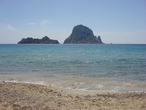
The 18th-century watchtower on the cliff facing Es Vedrà is the island's most famous viewpoint. Since 2020 the track has been closed to cars except for residents, so you walk up on a dirt track and path, with a steady climb and loose stones. Allow about 3 km there and back. Don't go near the edge or take shortcuts down to the sa Pedrera quarry. Everything about the islet, its viewpoints and how to get there without a car is in our guide to Es Vedrà.
8. Ses Salines: the ses Portes route
Flat, through the south of the natural park: from sa Canal, the old salt workers' village, along ses Salines beach and the juniper forest on the dunes to the 16th-century Torre de ses Portes, and back via es Cavallet. No shade: in summer, only first thing. We cover it in depth in Ses Salines Natural Park.
9. Ses Salines: the sa Sal Rossa route
The best for birdwatching. It starts at the church of Sant Francesc de s'Estany, with bird hides, follows the canal towards Playa d'en Bossa, passes the cave where the poets Rafael Alberti and María Teresa León hid in 1936 (there's a plaque) and reaches the Torre de sa Sal Rossa, built in the second half of the 16th century as a refuge for the salt workers. Return the same way; bring binoculars.
10. Es Broll de Buscastell
A short, green stroll through the Buscastell valley, between San Antonio and Santa Gertrudis. Es Broll is a spring that has always watered the valley's market gardens: you'll see irrigation channels, crops and farmhouses. Almost flat and perfect with children. On Saturday mornings you can combine it with the Forada farmers' market next door (details in Ibiza hippy markets).
11. Portinatx and the Moscarter lighthouse
From Portinatx, at the northern tip, a track and a path through pines and rock lead to the Moscarter lighthouse, the one with black and white stripes: its 52-metre tower, from 1977, is the tallest of any lighthouse in the Balearics. It's about 25-30 minutes each way (around 4 km there and back), with a gentle climb. On the way back, have a swim in the Portinatx coves. The T4 and T6 buses get there, with few departures.
12. Santa Eulària: the river and Puig de Missa
The town option. From the seafront in Santa Eulària des Riu you walk beside the river the municipality is named after (often described as the only river in the Balearics), cross the old bridge and climb Puig de Missa, the hill with the fortified church and views over the town and the sea. About 4 km in a loop, with one short climb.
Easy walks and hikes with kids
The easy walks that work best, children included:
- Pla de Corona (6.8 km, almost flat): it can be shortened and there's room to run around.
- Es Broll de Buscastell: short, with water and vegetable gardens.
- Sa Sal Rossa at ses Salines: flat, with birds to spot.
- Moscarter lighthouse: the lighthouse is the finish line and the cove the reward.
- Santa Eulària, river and Puig de Missa: with bars and toilets nearby.
With small children, avoid the clifftop routes (Cala Llentrisca, Torre des Savinar). Between January and April, watch out for processionary caterpillar nests in the pines: their stinging hairs are dangerous for children and dogs. More ideas in Ibiza with kids.
Waymarking, maps and apps
Ibiza doesn't have a large network of waymarked trails: there are public paths, tracks and footpaths with signboards on some stretches and nothing on others. So it's worth:
- Downloading the official track where one exists. Sant Josep publishes its walks and the two ses Salines routes with info sheets and tracks; Sant Antoni, its hiking and cycling routes in GPX and KMZ.
- Carrying an offline map on your phone. Apps based on OpenStreetMap show country paths well.
- Checking the public paths. Santa Eulària has a municipal catalogue of public paths by village, useful for knowing where you're allowed to walk.
Be wary of third-party tracks that cut across farms or take shortcuts down to the coves.
Rules on the trail: fire, dogs and private land
- Fire: banned on forest land from 1 May to 15 October. If you see smoke, call 112.
- Private land: almost all the countryside is privately owned. Respect "propietat privada" signs, close gates behind you and stay out of the crops.
- Dogs: on a lead in protected natural areas and near livestock. Bring water for them: there are no fountains. More in Ibiza with a dog.
- Protected areas (ses Salines, Es Amunts, the Cala d'Hort, Cap Llentrisca and sa Talaia natural park, Es Vedrà): stay on the paths and don't take plants or stones.
- Drones: check ENAIRE's restrictions first; the south is right next to the airport.
- Rubbish: whatever you carry up, carry down.
What to bring and common mistakes
Bring closed shoes with a good grip (the coastal limestone is sharp and slippery), plenty of water, a cap, sun cream, a windproof layer and a charged phone. On coastal walks, your swimmers.
Common mistakes:
- Setting off at midday in July with half a litre of water.
- Leaning over the cliff edge for a photo. The rock crumbles and the wind gusts.
- Not checking the last bus. The northern and beach routes have few departures; check Ibiza bus routes before you set out.
If you'd rather walk with company, in the Ibiza Connects app you can create a plan for a hike and see who joins, or share a car to the trailhead with car sharing. And if the walk ends at the sea, pick your cove in the Ibiza beaches guide.
Sources and official information
- Sant Josep de sa Talaia tourism · Passejos (walking routes with info sheets and tracks)
- Sant Josep tourism · Sa Talaia route
- Visit Sant Antoni · Hiking and cycling routes
- Visit Sant Antoni · Pla de Corona route
- Ajuntament de Santa Eulària des Riu · Municipal catalogue of public paths
- Transport Públic d'Eivissa (Alsa) · Routes and timetables 2026
- Fundació de Promoció Turística d'Eivissa · Nature
Frequently asked questions
What is the most beautiful hike in Ibiza?
For many people, the coast between Cala Salada and Punta Galera, for its cliffs and coves. For a one-of-a-kind view, the climb to Torre des Savinar facing Es Vedrà. And in January and February, the Pla de Corona loop with the almond trees in blossom is hard to beat.
What is the highest point in Ibiza?
Sa Talaia, in Sant Josep, at 475 metres. You can walk up from the village church in about 75 minutes on a 2.4 km path through pine forest, with a steeper final stretch. At the top there are antennas and viewpoints looking over San Antonio, ses Salines, Formentera and the western islets.
Are there easy walks in Ibiza for children?
Yes. The Pla de Corona in Santa Agnès, the es Broll de Buscastell stroll, the sa Sal Rossa route at ses Salines, the path to the Moscarter lighthouse in Portinatx and the Santa Eulària river walk are flat or nearly so. With children, avoid clifftop sections and the hottest hours of the day.
Can you go hiking in Ibiza in summer?
Yes, but carefully. Set off at sunrise, finish before 11:00, choose short routes that end at a cove and carry plenty of water. Remember that no fires of any kind are allowed in woodland at that time of year. For comfortable walking, October to May is much better.
Are Ibiza's hiking trails waymarked?
Only partly. There are signboards and posts on some stretches, but waymarking is patchy and many paths have none at all. Download the official track where there is one (Sant Josep and Sant Antoni publish them) and carry an offline map on your phone, because mobile coverage drops out in the north.
Can you reach the trailheads by bus?
Many of them, yes. Sant Josep (for Sa Talaia), San Antonio, Santa Eulària and Portinatx are on the 2026 bus network, and in season there are beach buses to ses Salines and Platges de Comte. Santa Agnès and Sant Mateu have very few departures: check the timetables before you go.